
پەڕگە:CH-NP 79-80 Bdy Map50.jpg
پەڕگەی سەرەکی (٣٬٢١٦ × ١٬٩٦٤ پیکسڵ، قەبارەی پەڕگە: ١٫١١ مێگابایت، جۆری ئێم ئای ئێم ئی: image/jpeg)
| وەسف |
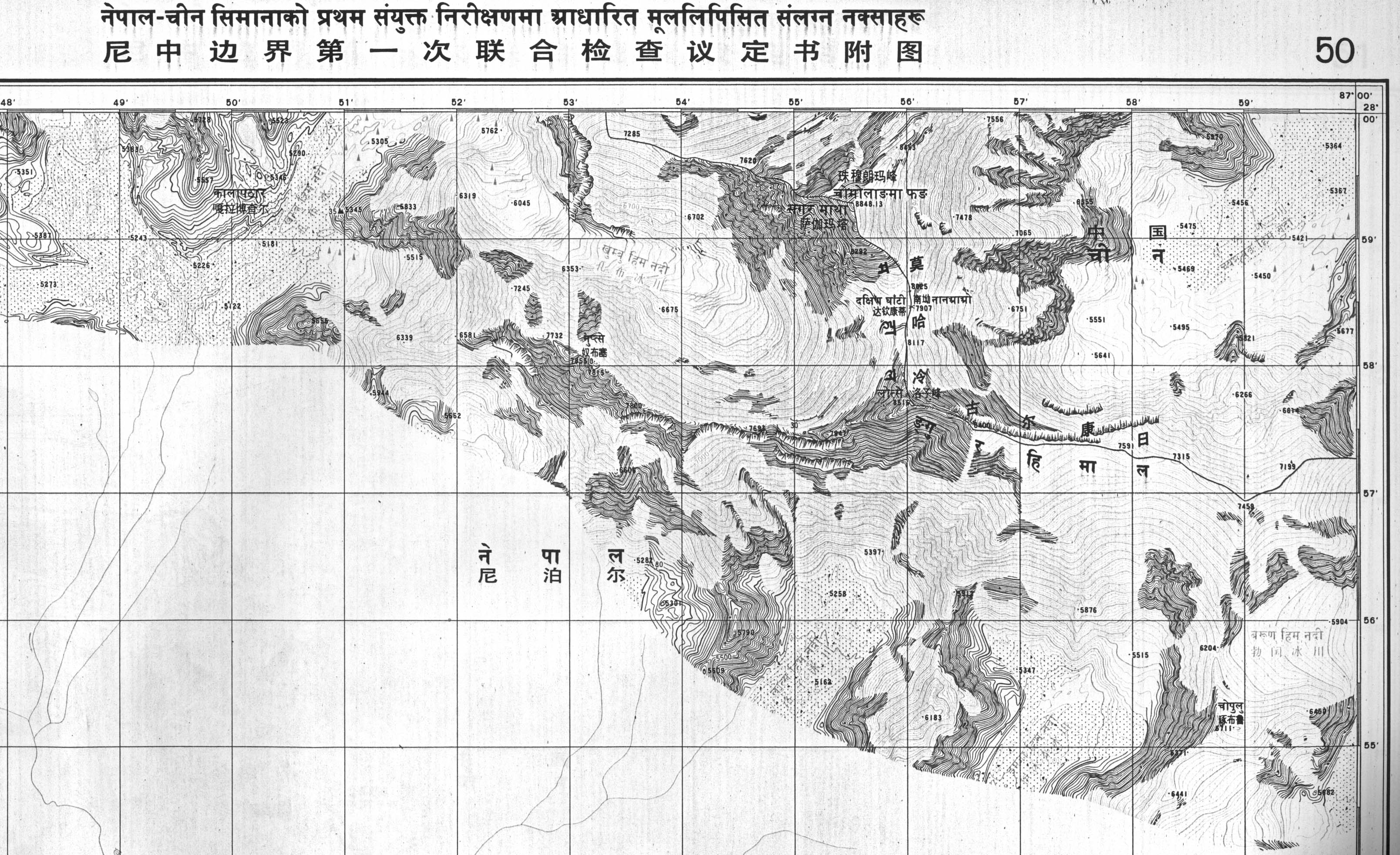
English: Boundary maps in the public domain published by the Survey of Nepal, sent to the UN |
| ڕێکەوت | |
| سەرچاوە | Boundary treaty maps held at UN Treaty Office |
| بەرھەمھێنەر | Survey of Nepal |
| This image is a map derived from a United Nations map.
Unless stated otherwise, UN maps are to be considered in the public domain. This applies worldwide. UN maps are, in principle, open source material and you can use them in your work or for making your own map. UN requests however that you delete the UN name, logo and reference number upon any modification to the map. Content of your map will be your responsibility. You can state in your publication, if you wish, something like: based on UN map … (map name, map number, revision number and date). See: Geospatial Information Section. And: Geospatial, location data for a better world. |
 |
مێژووی پەڕگە
کرتە بکە لەسەر یەکێک لە ڕێکەوت/کاتەکان بۆ بینینی پەڕگەکە بەو شێوەی لەو کاتەدا بووە.
| ڕێکەوت/کات | ھێما | ئەندازە | بەکارھێنەر | تێبینی | |
|---|---|---|---|---|---|
| هەنووکە | ٢١:٥٨، ١٦ی تشرینی دووەمی ٢٠١١ | | ٣٬٢١٦ لە ١٬٩٦٤ (١٫١١ مێگابایت) | DLinth | {{Information |Description ={{en|1=Boundary maps in the public domain published by the Survey of Nepal, sent to the UN}} |Source =Boundary treaty maps held at UN Treaty Office |Author =Survey of Nepal |Date =1980-07-01 |Permis |
بەکارھێنانی پەڕگە
ئەم پەڕەیە ئەم پەڕگەیە بەکار دەھێنێت:
بەکارھێنانی سەرانسەریی پەڕگە
ئەم ویکیانەی دیکەی خوارەوەش ئەم پەڕگە بەکاردێنن:
- بەکارھێنان لە cy.wikipedia.org
- بەکارھێنان لە en.wikipedia.org
- بەکارھێنان لە id.wikipedia.org
- بەکارھێنان لە zh.wikipedia.org