
پەڕگە:Wembley Stadium map.png

قەبارەی ئەم پێشبینینە: ٧٧٤ لە ٥٩٩ پیکسەڵ. ڕێزەلووشنەکانی تر: ٣١٠ لە ٢٤٠ پیکسەڵ | ٦٢٠ لە ٤٨٠ پیکسەڵ | ٩٩٢ لە ٧٦٨ پیکسەڵ | ١٬٢٣٢ لە ٩٥٤ پیکسەڵ.
پەڕگەی سەرەکی (١٬٢٣٢ × ٩٥٤ پیکسڵ، قەبارەی پەڕگە: ٩٤٨ کیلۆبایت، جۆری ئێم ئای ئێم ئی: image/png)
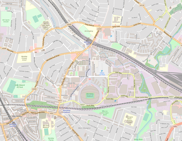
English: A map of England's Wembley Stadium in North West London, in relation to Olympic Way, Wembley Park/Central/Stadium stations, and the A406 (North Circular) Road (bottom right)
| Description |
This map was created from OpenStreetMap project data, collected by the community. This map may be incomplete, and may contain errors. Don't rely solely on it for navigation. |
| ڕێکەوت | 19 May 2010 |
| سەرچاوە | openstreetmap.org |
| ئافرێنەر |
OpenStreetMap contributors |
| ڕێپێدان (بەکارھێنانەوەی ئەم پەڕگەیە) |
OpenStreetMap data and maps are licensed under the Creative Commons Attribution-ShareAlike 2.0 license (CC-BY-SA 2.0). This file is licensed under the Creative Commons Attribution-Share Alike 2.0 Generic license.
|
| Georeferencing | If inappropriate please set warp_status = skip to hide. |
مێژووی پەڕگە
کرتە بکە لەسەر یەکێک لە ڕێکەوت/کاتەکان بۆ بینینی پەڕگەکە بەو شێوەی لەو کاتەدا بووە.
| ڕێکەوت/کات | ھێما | ئەندازە | بەکارھێنەر | تێبینی | |
|---|---|---|---|---|---|
| هەنووکە | ٢٠:١٠، ٢٦ی تەممووزی ٢٠٢١ | | ١٬٢٣٢ لە ٩٥٤ (٩٤٨ کیلۆبایت) | Boothy m | Updated map to July 2021 version of OpenStreetMap's standard layer, exported from https://www.openstreetmap.org/#map=15/51.5593/-0.2813 |
| ١٣:٤٥، ١٩ی ئایاری ٢٠١٠ |  | ١٬١٤١ لە ٨٦٧ (٤٩٧ کیلۆبایت) | Ultra7 | {{en|A map of England's {{w|Wembley Stadium}} in North West London, in relation to Olympic Way, Wembley Park/Central/Stadium stations, and the A406 (North Circular) Road (bottom right)}} {{OpenStreetMap|date=19 May 2010}} Category:Wembley Stadium |
بەکارھێنانی پەڕگە
ئەم پەڕەیە ئەم پەڕگەیە بەکار دەھێنێت:
بەکارھێنانی سەرانسەریی پەڕگە
ئەم ویکیانەی دیکەی خوارەوەش ئەم پەڕگە بەکاردێنن:
- بەکارھێنان لە af.wikipedia.org
- بەکارھێنان لە az.wikipedia.org
- بەکارھێنان لە be.wikipedia.org
- بەکارھێنان لە bg.wikipedia.org
- بەکارھێنان لە bn.wikipedia.org
- بەکارھێنان لە ca.wikipedia.org
- بەکارھێنان لە cs.wikipedia.org
- بەکارھێنان لە el.wikipedia.org
- بەکارھێنان لە en.wikipedia.org
- بەکارھێنان لە et.wikipedia.org
- بەکارھێنان لە eu.wikipedia.org
- بەکارھێنان لە fr.wikipedia.org
- بەکارھێنان لە gl.wikipedia.org
- بەکارھێنان لە hi.wikipedia.org
- بەکارھێنان لە hr.wikipedia.org
- بەکارھێنان لە hu.wikipedia.org
- بەکارھێنان لە hy.wikipedia.org
- بەکارھێنان لە id.wikipedia.org
- بەکارھێنان لە it.wikipedia.org
- بەکارھێنان لە ja.wikipedia.org
- بەکارھێنان لە jv.wikipedia.org
- بەکارھێنان لە ka.wikipedia.org
- بەکارھێنان لە lt.wikipedia.org
- بەکارھێنان لە mn.wikipedia.org
- بەکارھێنان لە mr.wikipedia.org
- بەکارھێنان لە nl.wikipedia.org
- بەکارھێنان لە ro.wikipedia.org
- بەکارھێنان لە sk.wikipedia.org
- بەکارھێنان لە th.wikipedia.org
- بەکارھێنان لە tr.wikipedia.org
- بەکارھێنان لە vi.wikipedia.org
- بەکارھێنان لە xmf.wikipedia.org
- بەکارھێنان لە zh.wikipedia.org