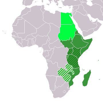
پەڕگە:LocationEasternAfrica.png
LocationEasternAfrica.png (٣٥٩ × ٣٥٩ پیکسڵ، قەبارەی پەڕگە: ٨ کیلۆبایت، جۆری ئێم ئای ئێم ئی: image/png)
مێژووی پەڕگە
کرتە بکە لەسەر یەکێک لە ڕێکەوت/کاتەکان بۆ بینینی پەڕگەکە بەو شێوەی لەو کاتەدا بووە.
| ڕێکەوت/کات | ھێما | ئەندازە | بەکارھێنەر | تێبینی | |
|---|---|---|---|---|---|
| هەنووکە | ١٣:١٦، ١١ی تشرینی دووەمی ٢٠٢٢ |  | ٣٥٩ لە ٣٥٩ (٨ کیلۆبایت) | ColorfulSmoke | . |
| ١١:٥٤، ١١ی تشرینی دووەمی ٢٠٢٢ |  | ٣٦٠ لە ٣٥٩ (٨ کیلۆبایت) | ColorfulSmoke | ||
| ١٧:٠١، ١٧ی ئازاری ٢٠١٨ |  | ٣٦٠ لە ٣٩٢ (١١ کیلۆبایت) | Maphobbyist | Upload | |
| ٠٠:٣٠، ٢٠ی کانوونی یەکەمی ٢٠١٢ |  | ٣٦٠ لە ٣٩٢ (٨ کیلۆبایت) | Spacepotato | Recolor to reflect placement of South Sudan in Eastern Africa according to the UN classification scheme, http://unstats.un.org/unsd/methods/m49/m49regin.htm . | |
| ١٧:٠١، ٩ی تەممووزی ٢٠١١ |  | ٣٦٠ لە ٣٩٢ (١٤ کیلۆبایت) | Maphobbyist | South Sudan has become independent on July 9, 2011. Sudan and South Sudan are shown with the new international border between them. | |
| ٠٨:١٥، ١١ی کانوونی یەکەمی ٢٠٠٧ |  | ٣٦٠ لە ٣٩٢ (١٤ کیلۆبایت) | Hoshie | added Cabinda (Angola) and Montenegro. | |
| ١٥:٥٦، ٢ی نیسانی ٢٠٠٦ |  | ٣٦٠ لە ٣٩٢ (٩ کیلۆبایت) | E Pluribus Anthony~commonswiki | Reverted to earlier revision | |
| ٠٥:٤٧، ١ی نیسانی ٢٠٠٦ |  | ٣٦٠ لە ٣٩٢ (١٤ کیلۆبایت) | Aris Katsaris | No need to include regional organizations -- it makes the map much harder to read for no relevant purpose. The map should be clear in its purpose. | |
| ١٢:٣٧، ٥ی شوباتی ٢٠٠٦ |  | ٣٦٠ لە ٣٩٢ (٩ کیلۆبایت) | E Pluribus Anthony~commonswiki | Map: Eastern Africa (location) |
بەکارھێنانی پەڕگە
ئەم پەڕەیە ئەم پەڕگەیە بەکار دەھێنێت:
بەکارھێنانی سەرانسەریی پەڕگە
ئەم ویکیانەی دیکەی خوارەوەش ئەم پەڕگە بەکاردێنن:
- بەکارھێنان لە ace.wikipedia.org
- بەکارھێنان لە af.wikipedia.org
- بەکارھێنان لە als.wikipedia.org
- بەکارھێنان لە am.wikipedia.org
- بەکارھێنان لە ar.wikipedia.org
- ليبيا
- جيبوتي
- موريتانيا
- تونس
- السودان
- الصحراء الغربية
- أنغولا
- أوغندا
- إسبانيا
- تشاد
- النيجر
- مالي
- السنغال
- غامبيا
- غينيا بيساو
- غينيا
- سيراليون
- ليبيريا
- غانا
- توغو
- بنين
- بوركينا فاسو
- الصومال
- كينيا
- تنزانيا
- الغابون
- زامبيا
- موزمبيق
- زيمبابوي
- البرتغال
- الكاميرون
- جمهورية الكونغو الديمقراطية
- بوتسوانا
- جنوب إفريقيا
- جمهورية إفريقيا الوسطى
- جمهورية الكونغو
- سيشل
- ناميبيا
- مدغشقر
- ليسوتو
- موريشيوس
- نهر النيل
بینینی بەکارھێنانی گشتی زیاتری ئەم پەڕگەیە.


