
پەڕگە:Korean Peninsula satellite.png

پەڕگەی سەرەکی (١٬٢٧٨ × ٩٥٢ پیکسڵ، قەبارەی پەڕگە: ١٫٢٧ مێگابایت، جۆری ئێم ئای ئێم ئی: image/png)
کورتە
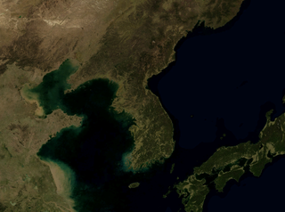
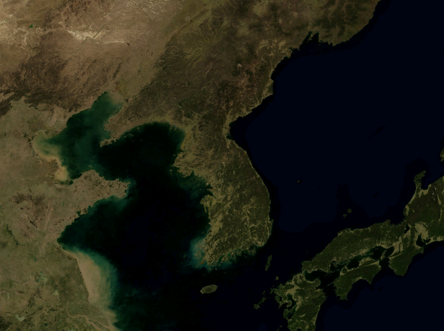
| وەسف | Satellite image of Korean Peninsula | ||
| سەرچاوە | NASA World Wind Globe, version 1.4 | ||
| بەرھەمھێنەر | وێنە: NASA | ||
| ڕێپێدان (بەکارھێنانەوەی ئەم پەڕگەیە) |
This screenshot either does not contain copyright-eligible parts or visuals of copyrighted software, or the author has released it under a free license (which should be indicated beneath this notice), and as such follows the licensing guidelines for screenshots of Wikimedia Commons. You may use it freely according to its particular license. Free software license:
Note: if the screenshot shows any work that is not a direct result of the program code itself, such as a text or graphics that are not part of the program, the license for that work must be indicated separately. |

مۆڵەتنامە
| This image is in the public domain because it is a screenshot from NASA’s globe software World Wind using a public domain layer, such as Blue Marble, MODIS, Landsat, SRTM, USGS or GLOBE.
|
 |
مێژووی پەڕگە
کرتە بکە لەسەر یەکێک لە ڕێکەوت/کاتەکان بۆ بینینی پەڕگەکە بەو شێوەی لەو کاتەدا بووە.
| ڕێکەوت/کات | ھێما | ئەندازە | بەکارھێنەر | تێبینی | |
|---|---|---|---|---|---|
| هەنووکە | ٢٣:٤٠، ٢٥ی تشرینی دووەمی ٢٠٠٨ | | ١٬٢٧٨ لە ٩٥٢ (١٫٢٧ مێگابایت) | Jyusin | {{Information |Description=Satellite image of Korean Peninsula |Source=NASA World Wind Globe, version 1.4 |Date= |Author=<!-- software author / developer team --> |Permission={{free screenshot|license={{GPL}}}} |other_versions= }} [[Category:Korean Penins |
بەکارھێنانی پەڕگە
ئەم پەڕەیە ئەم پەڕگەیە بەکار دەھێنێت:
بەکارھێنانی سەرانسەریی پەڕگە
ئەم ویکیانەی دیکەی خوارەوەش ئەم پەڕگە بەکاردێنن:
- بەکارھێنان لە bg.wikipedia.org
- بەکارھێنان لە ca.wikipedia.org
- بەکارھێنان لە en.wikipedia.org
- بەکارھێنان لە es.wikipedia.org
- بەکارھێنان لە fa.wikipedia.org
- بەکارھێنان لە he.wikipedia.org
- بەکارھێنان لە id.wikipedia.org
- بەکارھێنان لە ja.wikipedia.org
- بەکارھێنان لە ko.wikipedia.org
- بەکارھێنان لە mzn.wikipedia.org
- بەکارھێنان لە nl.wikipedia.org
- بەکارھێنان لە no.wikipedia.org
- بەکارھێنان لە pt.wikipedia.org
- بەکارھێنان لە ru.wikipedia.org
- بەکارھێنان لە tg.wikipedia.org
- بەکارھێنان لە tr.wikipedia.org
- بەکارھێنان لە vi.wikipedia.org
- بەکارھێنان لە www.wikidata.org
- بەکارھێنان لە zh.wikipedia.org