
پەڕگە:Dead Sea Galilee.jpg

قەبارەی ئەم پێشبینینە: ٣٦٣ لە ٦٠٠ پیکسەڵ. ڕێزەلووشنەکانی تر: ١٤٥ لە ٢٤٠ پیکسەڵ | ٢٩٠ لە ٤٨٠ پیکسەڵ | ٤٦٥ لە ٧٦٨ پیکسەڵ | ١٬١٦٢ لە ١٬٩٢٠ پیکسەڵ.
پەڕگەی سەرەکی (١٬١٦٢ × ١٬٩٢٠ پیکسڵ، قەبارەی پەڕگە: ٦٤٥ کیلۆبایت، جۆری ئێم ئای ئێم ئی: image/jpeg)
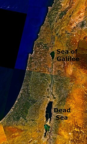
Outdated 1948-1967 geopolitical map depicting Jordanian conquest territory with Dead Sea and the w:Sea of Galilee.
| This image is in the public domain because it is a screenshot from NASA’s globe software World Wind using a public domain layer, such as Blue Marble, MODIS, Landsat, SRTM, USGS or GLOBE.
|
 |
مێژووی پەڕگە
کرتە بکە لەسەر یەکێک لە ڕێکەوت/کاتەکان بۆ بینینی پەڕگەکە بەو شێوەی لەو کاتەدا بووە.
| ڕێکەوت/کات | ھێما | ئەندازە | بەکارھێنەر | تێبینی | |
|---|---|---|---|---|---|
| هەنووکە | ١٨:٠٧، ٢٤ی ئابی ٢٠٠٦ | | ١٬١٦٢ لە ١٬٩٢٠ (٦٤٥ کیلۆبایت) | Interiot~commonswiki | The Dead Sea and the w:Sea of Galilee. Imagery from NASA World Wind. {{PD-USGov-NASA}} Category:Satellite pictures of IsraelCategory:Satellite pictures of Jordan |
بەکارھێنانی پەڕگە
ئەم پەڕەیە ئەم پەڕگەیە بەکار دەھێنێت:
بەکارھێنانی سەرانسەریی پەڕگە
ئەم ویکیانەی دیکەی خوارەوەش ئەم پەڕگە بەکاردێنن:
- بەکارھێنان لە bn.wikipedia.org
- بەکارھێنان لە da.wikipedia.org
- بەکارھێنان لە el.wiktionary.org
- بەکارھێنان لە en.wikipedia.org
- بەکارھێنان لە en.wiktionary.org
- بەکارھێنان لە fo.wikipedia.org
- بەکارھێنان لە fr.wiktionary.org
- بەکارھێنان لە fy.wikipedia.org
- بەکارھێنان لە id.wikipedia.org
- بەکارھێنان لە kn.wikipedia.org
- بەکارھێنان لە ku.wikipedia.org
- بەکارھێنان لە ml.wikipedia.org
- بەکارھێنان لە ms.wikipedia.org
- بەکارھێنان لە pt.wikipedia.org
- بەکارھێنان لە ro.wikipedia.org
- بەکارھێنان لە sc.wikipedia.org
- بەکارھێنان لە simple.wikipedia.org
- بەکارھێنان لە sl.wikipedia.org
- بەکارھێنان لە sw.wikipedia.org
- بەکارھێنان لە te.wiktionary.org
- بەکارھێنان لە ur.wikipedia.org
- بەکارھێنان لە zh.wikipedia.org
- بەکارھێنان لە zh.wiktionary.org